How do bike-sharing schemes shape cities?

"NEXT month a so-called "brand new means of transport" will be launched in Copenhagen: the bicycle. GoBike, Europe's latest bike-sharing scheme, will have bicycles with built-in tablet computers that direct cyclists to the best local restaurants, show offers in nearby shops and give the latest train times. Bike-sharing is shifting up a gear: it seems that nearly every self-respecting mayor is either developing a scheme or announcing an expansion to one. What is the impact on cities' development?
Bike-sharing began in the 1960s when 50 "free bikes" were scattered around Amsterdam. They were promptly stolen. But after this slow start bike-sharing has blossomed. Over the past decade the number of schemes has increased tenfold. Bike-sharing ventures now exist in more than 500 cities, from Dubai to Hawaii. Each works on the simple principle that a user can borrow a bike at a docking station and then return it to another. The first 30 minutes are usually free. The most successful schemes have large fleets of bikes, lots of small docking stations and a few "superdocks" in busy places, such as train stations. Electronic monitoring of the bikes can show ebbs and flows of bike traffic through cities, allowing better distribution of bikes and planning of new docks.
Just as mass public transport changed the development of cities' suburbs, bike-hire schemes are now shaping city centres in subtle ways. A "cycling census" in London found that in the morning rush-hours nearly half of all northbound traffic crossing three of the city's main bridges was made up of cyclists. Planners have responded by criss-crossing the city with cycle-paths; more are proposed. Some mayors are experimenting with bike-only days: Mexico City, the unlikely home of a highly popular bike-hire scheme, closes its central eight-lane highway to cars every Sunday, to the rage of motorists. Property developers are taking note, too: just as houses near metro stations tend to command higher prices, research now suggests that access to cycle paths and proximity to docking points is linked to higher rents. Finally, bike-sharing opens up parts of cities that were previously hard to access by public transport, especially late at night when bus and train services get thinner. Research by Susan Shaheen at the University of California, Berkeley, found that in Montreal and Toronto four out of ten people shopped more at locations near bike stations. In Washington, DC, more than eight out of ten said they were more likely to visit a business, shop or restaurant with easy access to bike-sharing dock.
Just as researchers begin to grasp the impact of bike-sharing, the schemes themselves continue to evolve at speed. New developments include much cheaper "dockless" bikes, already in use in Berlin, which can be found by mobile phone. Another promising development is the introduction of electric bikes, for longer or steeper journeys. Such innovations could help broaden the appeal of bike-share schemes beyond their current users, who are mainly young, relatively well-off men. Bike sharing is just one part of a broader movement towards alternative forms of transport in increasingly crowded cities, but it could be an important one. As last year’s United States Conference of Mayors concluded: "communities that have invested in pedestrian and bicycle projects have benefited from improved quality of life, healthier population, greater local real-estate values, more local travel choices, and reduced air pollution." Time for more of the world to go Dutch."

Pedalling myths: the anti-bike lobby is flat out of plausible arguments

Menace to society: a woman cycling in New York. Photograph: Thomas Grass/Getty Images

"With the 'bikelash' reduced to incoherent rants, pro-car common sense is losing traction. Allow me to ride to the rescue.

If you hold the view that bikes, and bike lanes, are among the greatest evils threatening society today, you might at first have been pleased to see this week's Toronto Sun column by Mike Strobel, which has circulated widely online. Initially, it appears to stand in the fine tradition of anti-bike screeds such as those by the New York Post's Steve Cuozzo or Andrea Peyser, or the New Yorker's John Cassidy. All are on the frontlines of what's been called the "bikelash", brave fighters willing to stand firm against the growing popularity of cycling across north America. (One of the most prominent developments, New York's long-awaited bikeshare program, is due to launch next month.)
Take a closer look, though, and you'll notice that something's amiss with Strobel's piece. The average bikelash commentator, no matter how dyspeptic, considers him or herself obliged to come up with some sort of argument. That's why, for example, you'll see Peyser paying vastly disproportionate attention to the tiny number of truly awful accidents caused by cyclists. It's why Cuozzo likes to conduct dubious amateur surveys to try to show that nobody uses bike lanes. But Strobel's rant against what he calls the "bicycult" is almost entirely devoid of argument. This is as close as he gets:
"The nitty-gritty: Streets are designed for cars, not bikes. Especially in winter, which is most of the time … Cars are common sense. They are our era's horses. They're also vastly greener and safer than your dad's Buick. They will never go dinosaur, despite the bike cult's best efforts."
Still, you've got to sympathise with Strobel's predicament. All the major cycling-related arguments have been won: bike lanes are popular; they don't hurt local businesses; more biking doesn't lead to more accidents; bike lanes make pedestrians safer and don't impede the flow of car traffic.
To anyone who agrees that cycling, much like genocide, is a phenomenon that all decent people should condemn, the implication is clear: the anti-bike lobby urgently needs some new arguments. It's my honour, therefore, to suggest a few they might like to use:
1. In some contexts, bikes are much more dangerous than cars. Consider a heavy bike, dropped from a height of 20ft onto a playground where numerous small children are playing, innocently unaware of the tragedy about to befall them. Now compare this to a car parked on a quiet street. Only the most biased, Brooklyn-dwelling NPR listener could deny the obvious: the bike, in this example, is much, much more dangerous.
2. If you support gun control, you should support bike control. Milquetoast liberals are always objecting to the argument that "guns don't kill people, people kill people", because the widespread availability of guns makes it more likely they'll be used for nefarious purposes. Well, just follow the logic. Bikes can be used for nefarious purposes, too: consider scenario 1 above, or the popularity of bikes among drug-dealers. It's a no-brainer, therefore, that bicycles should be subject to the same kind of ban currently proposed, in the US, for semi-automatic weapons.
3. Any true progressive should support cars over bicycles. The first bicycle dates from 1817. The first car dates from 1886. Are you a progressive or aren't you?
4. The popularity of bikes leads to newspaper "trend stories" like this one, about how some women who ride bikes also wear fashionable clothes. This is actually a pretty good argument.
5. Cyclists are bad people. Let's give Strobel some credit here: he points to Lance Armstrong, whose case proves that all cyclists are liars. It also seems likely that, in the near future, neuroscientific research will confirm that the same part of the brain lights up when cycling as when committing serial murder. The evidence isn't in yet, but are we really going to wait to dot every "i" and cross every "t" before taking action to counter the horrendous possibilities?
OK, that should do for now. Take heart, bikelash commentators! Now is not the time to backpedal. Steel yourselves and keep fighting, until that glorious day when bikes are gone forever".

Trees can help with soot pollution, study finds

Volunteers with Baltimore Tree Trust weed and mulch trees in the 400 block of N. Luzerne Ave. From left are: Arielle Brown, 19; Kiara Carter, 21, and her sister, Kiana Carter, 18. In the foreground right is Shahem McLaurin, 19. (Algerina Perna, Baltimore Sun / July 9, 2013)

"Though diminished, Baltimore's canopy helps reduce ER visits, deaths


Trees do more than just clear the air and provide shade from the hot summer sun. Though no panacea, they can make cities like Baltimore healthier, a recent study suggests.
Using computer modeling to quantify the health benefits of trees in 10 cities, including Baltimore, researchers with the U.S. Forest Service and a private think tank say leafy foliage in urban areas can scrub enough soot out of the air to reduce asthma attacks, emergency room visits and even deaths.
"It's the first time we've actually been able to tie it to human health, which is pretty exciting," said David J. Nowak, a federal research forester and lead author of the report. Collaborating on the study was the Davey Institute, the research arm of an Ohio-based tree care company.
Scientists have long scrutinized how trees affect smog, or ozone pollution. This study, published online in the journal Environmental Pollution, focused on another pollutant — fine particles, or soot — and estimated the benefits that trees provide in breathing problems avoided and lives saved.
In Baltimore, researchers figured, trees remove roughly 14 tons of pollution annually. As a result, they concluded, there's one less premature death, nearly 140 fewer asthma attacks and 240 cases of labored breathing avoided in Baltimore each year.
Urban air is swimming in fine particles from car and truck exhaust, power plant emissions, wood smoke and various industrial processes. The smallest particles, those measuring less than one-seventh the width of a human hair, can become lodged deep in the lungs. There, they can aggravate respiratory or cardiovascular conditions and lead to premature death. Fine-particle exposure has been linked to a variety of health problems, including asthma, heart attacks and lung cancer.
Laboratory studies have shown that tree leaves can act as filters, collecting particles from the air. Every so often, rainfall washes the buildup off the leaves to the ground. But stiff winds also can knock particles off the leaves back into the air.
"It's like when you have a dirty shirt and shake it real hard," Nowak said.
For cities like Atlanta with abundant tree canopy, the pollution-removing effect of leaves is greatest. But the impact on people's health is more pronounced in the most populous cities, such as New York, where the study estimated that up to eight deaths were avoided.
The health benefits of trees are about average in Baltimore. But that's not necessarily going to stay that way. The city has been losing trees and canopy over the past decade at least, Nowak said, and they now cover just 27 percent of the landscape. Depending on who's counting, 16 percent to 20 percent of what's left is considered distressed, diseased or dying.
The city has vowed to increase tree cover to 40 percent of the landscape by 2040. But the city's tree-planting efforts are less than half what would be needed to reach that goal, according to the Baltimore Tree Trust, a nonprofit dedicated to re-leafing the city. Groups like the trust are trying to supplement the work of the cash-strapped municipal government.
Amanda Cunningham, the trust's executive director, said that "in the microscopic world of atmospheric pollutants, you can see and feel the difference a tree makes in improving the air you breathe and the temperature of that air."
The group is focusing planting efforts on urban neighborhoods with the highest asthma rates and the fewest trees. Its first project is McElderry Park in Southeast Baltimore, where volunteers have put in 154 big trees in the past year, Cunningham said. The trust hopes to add 650 more in the next few years — enough to boost tree cover there from 13 percent to the citywide goal of 40 percent.
"With one of the city's highest rates of emergency room visits by children for treatment of asthma," Cunningham said in an email, "the residents of McElderry Park, will hopefully breathe a little easier as they take action to change the environmental conditions where they live."
But trees are not a cheap fix for air pollution, Nowak cautioned. A dense canopy of trees may trap emissions, he said, preventing them from being dispersed by winds. Pollution can damage trees, undermining their environmental benefits. Ozone, a highly reactive gas in smog, can burn foliage, while fine particles can lodge themselves in the stomata, or pores, of leaves, preventing them from taking in carbon dioxide and giving off oxygen and water vapor.
Another recent study has suggested that trees exposed to air pollution can actually make it worse under certain circumstances. Isoprene, an organic compound given off by trees to protect their leaves, reacts with nitrogen oxides from vehicle exhaust, power plants and other sources to produce fine particles, the study found.
Nowak said he hopes this line of research can help urban communities plan better where and how to plant trees, to maximize their benefits.
"We know trees en masse have this removal effect,'' he concluded. "But at a local level they can either remove pollution or increase it, depending on the design."
tim.wheeler@baltsun.com".

Transporte de Bicicletas no Metropolitano de Lisboa


"Pode-se transportar bicicletas no Metro, no máximo de duas bicicletas por carruagem, desde que não se verifiquem grandes aglomerações de passageiros nem seja perturbado o normal funcionamento do sistema".

Fonte e imagem: http://www.metrolisboa.pt/informacao/viajar-no-metro/utilizacao-do-metro/

Bicicleta roubada XV


Bicicleta Órbita, roubada no interior de um prédio em frente à Assembleia da República.
(Hoje: 05.09.2013)

Stranded by Sprawl, por Paul Krugman

"Detroit is a symbol of the old economy’s decline. It’s not just the derelict center; the metropolitan area as a whole lost population between 2000 and 2010, the worst performance among major cities. Atlanta, by contrast, epitomizes the rise of the Sun Belt; it gained more than a million people over the same period, roughly matching the performance of Dallas and Houston without the extra boost from oil.
Yet in one important respect booming Atlanta looks just like Detroit gone bust: both are places where the American dream seems to be dying, where the children of the poor have great difficulty climbing the economic ladder. In fact, upward social mobility — the extent to which children manage to achieve a higher socioeconomic status than their parents — is even lower in Atlanta than it is in Detroit. And it’s far lower in both cities than it is in, say, Boston or San Francisco, even though these cities have much slower growth than Atlanta.
So what’s the matter with Atlanta? A new study suggests that the city may just be too spread out, so that job opportunities are literally out of reach for people stranded in the wrong neighborhoods. Sprawl may be killing Horatio Alger.
The new study comes from the Equality of Opportunity Project, which is led by economists at Harvard and Berkeley. There have been many comparisons of social mobility across countries; all such studies find that these days America, which still thinks of itself as the land of opportunity, actually has more of an inherited class system than other advanced nations. The new project asks how social mobility varies across U.S. cities, and finds that it varies a lot. In San Francisco a child born into the bottom fifth of the income distribution has an 11 percent chance of making it into the top fifth, but in Atlanta the corresponding number is only 4 percent.
When the researchers looked for factors that correlate with low or high social mobility, they found, perhaps surprisingly, little direct role for race, one obvious candidate. They did find a significant correlation with the existing level of inequality: “areas with a smaller middle class had lower rates of upward mobility.” This matches what we find in international comparisons, where relatively equal societies like Sweden have much higher mobility than highly unequal America. But they also found a significant negative correlation between residential segregation — different social classes living far apart — and the ability of the poor to rise.
And in Atlanta poor and rich neighborhoods are far apart because, basically, everything is far apart; Atlanta is the Sultan of Sprawl, even more spread out than other major Sun Belt cities. This would make an effective public transportation system nearly impossible to operate even if politicians were willing to pay for it, which they aren’t. As a result, disadvantaged workers often find themselves stranded; there may be jobs available somewhere, but they literally can’t get there.
The apparent inverse relationship between sprawl and social mobility obviously reinforces the case for “smart growth” urban strategies, which try to promote compact centers with access to public transit. But it also bears on a larger debate about what is happening to American society. I know I’m not the only person who read the Times article on the new study and immediately thought, “William Julius Wilson.”
A quarter-century ago Mr. Wilson, a distinguished sociologist, famously argued that the postwar movement of employment out of city centers to the suburbs dealt African-American families, concentrated in those city centers, a heavy blow, removing economic opportunity just as the civil rights movement was finally ending explicit discrimination. And he further argued that social phenomena such as the prevalence of single mothers, often cited as causes of lagging black performance, were actually effects — that is, the family was being undermined by the absence of good jobs.
These days, you hear less than you used to about alleged African-American social dysfunction, because traditional families have become much weaker among working-class whites, too. Why? Well, rising inequality and the general hollowing out of the job market are probably the main culprits. But the new research on social mobility suggests that sprawl — not just the movement of jobs out of the city, but their movement out of reach of many less-affluent residents of the suburbs, too — is also playing a role.
As I said, this observation clearly reinforces the case for policies that help families function without multiple cars. But you should also see it in the larger context of a nation that has lost its way, that preaches equality of opportunity while offering less and less opportunity to those who need it most".

Morreu o artista que iluminou o deserto: Walter De Maria

The Lightning Field: 400 hastes metálicas dispostas numa área de um quilómetro no deserto do Novo México

"Tinha desejo de espaço, de viagem, levou a produção artística a uma escala inédita na sua relação com a natureza.
 
Walter De Maria, uma dos nomes mais conhecidos da land art, morreu com 77 anos, na quinta-feira em Los Angeles, durante o sono, provavelmente vítima de um enfarte. Considerado pela ensaísta e historiadora Rosalind Krauss um dos artistas que expandiu o campo da escultura, inscreveu a sua assinatura na história da produção cultural e artística da segunda metade do seculo XX, antes de iniciar um período de reclusão que o afastou das principais instâncias de divulgação e mediatização da arte.
Durante 50 anos, o seu trajecto espelhou as aspirações, a energia e o inconformismo que ficou associado aos finais da década 1960 e aos primeiros anos da década seguinte. Começou por estudar História e Arte em São Francisco, inclinando-se para a pintura, mas o contacto com as obras do músico La Monte Young e da coreógrafa Simone Forti desviaram-no na direcção da escultura. Nesse período, desenvolve trabalhos que integram linguagem, instruções, texto, e que apontam para afinidades com o conceptualismo, mas expõe pouco. Em 1960 aterra em Nova Iorque e começa a usar pequenas formas geométricas e materiais como alumínio e aço, expondo em apartamentos e galerias, participando em happenings, fazendo filmes. Imerso na cena downtown da cidade, reaviva, por um curto e intenso período, o seu interesse pela música. Integra como baterista os The Primitives, a banda que seria a antecâmara dos Velvet Underground, ensaia com Don Cherry, e grava em 1964 e 1968, respectivamente, Cricket Music e Ocean Music, discos que misturam sons naturais e provindos de instrumentos; e que, depois de uma reedição limitada em 2002, continuam indisponíveis.

Desejo de espaço
Também em Nova Iorque reencontra Robert Whitman, com quem gere uma galeria, e testemunha os primeiros desenvolvimento do minimalismo. Entretanto já domina o trabalho com o aço e o alumínio e imagina-se em trabalhar numa escala que as condições de Nova Iorque não permitem. Inspirado por desenhos que vem realizando, pelas memórias visuais da Costa Oeste, pela beat-generation, tem desejo de espaço, de viagem. Vive em Nova Iorque, mas pensa no Pólo Sul, no deserto do Sara, nas montanhas do Canadá. Não quer que o trabalho seja julgado pelo contexto social e espacial que a galeria impõe. Tem o apoio da Dwan Galerry, viaja ao deserto de Nevada, ao Sul do EUA, a Munique, onde apresenta uma instalação de terra que 1977 será rebaptizada de New York Earth Room. Mas a primeira obra que os críticos classificam de earthwork é Mile Long Drawing, de 1968, um “desenho” de longas e paralelas linhas de giz sobre o Deserto do Mojave.

Em 1977 apresenta uma das suas mais famosas peças, The Lightning Field: 400 hastes metálicas dispostas numa área de um quilómetro no deserto do Novo México. Compõem um retângulo, uma escultura geométrica, cuja experiência surge determinada pelos efeitos das condições atmosféricas sobre a luz e as cores da paisagem. Pode ser apreciada de madrugada, ao nascer do sol ou sob uma tempestade (as hastes atraem a eletricidade da relâmpagos). Para um trabalho que só acontece com a presença física do espectador no lugar, torna-se uma das obras mais icónicas de Walter De Maria, acabando reproduzida em várias revistas e citada no romance Blinded by the Light by Morgan Hunt.

Embora preferindo expor em espaços amplos e exteriores, não deixou de marcar presença em galerias e certames internacionais. De um conjunto notável, destacam-se Primary Structures no Jewish Museum, em 1966, momento marcante do minimalismo e, três anos depois, When Attitude Becomes Form, na Kunsthalle de Berna, colectiva que assinalava o advento do pós-minimalismo. Refira-se igualmente as participações nas Documentas de Kassel de 1968 e 1977 e uma retrospectiva no Kunstmuseum de Basileia em 1972. Nos anos 1970, contava já com apoio da Dia Foundation e do coleccionador Heiner Friedrich que se tornaria fundamental para a realização de obras ainda disponíveis à experiência dos espectadores: a já citada The Lightning Field, The Vertical Earth Kilometer em Kassel (1977) ou The Broken Kilometer em Nova Iorque (1979), que estaria na origem The 2000 Sculpture (1992).

Artista que nas últimas décadas se foi tornado invisível (no mundo da arte), deixou-nos obras onde não faltam sentido de humor, conceitos, aventura, espaço. Mas para muitos dos seus pares mais jovens, e até para curadores de renome, tornou-se personalidade relativamente obscura. Há dois anos, Richard Aldrich, do Dia Foundation, lamentava a ausência de monografias sobre o artista e reivindicava a descoberta de trabalhos que lançavam uma nova luz sobre a sua produção. Pode ser que nos próximos anos essa investigação ganhe um novo fôlego, agora que Walter De Maria desapareceu".
 

Car-free in cities where driving is king

Brian Poole, in Vancouver, ditched his car for a monthly bus pass and his bicycle. (Michelle Ty)

By Alina Dizik
"As hourly car rentals, taxi-hailing apps and car-sharing services become more popular, some drivers are finding ownership unnecessary.

Robust public transportation and easy access to necessities, coupled with the high costs of everything from tolls to parking have long led to car-free living in places like New York, Singapore and many European capitals. But, emerging transport options — think Uber, Halo, RelayRides and Zipcar — are spreading to cities where having a car had been a near-necessity. At the same time, the cost of car ownership is rising. In the last year, maintenance costs in the United States for a vehicle rose 11.3%, while insurance premiums rose 2.7%, according to the American Automobile Association’s 2013 Your Driving Costs. The average cost to operate a vehicle in the US was $8,946 in 2012 and that figure is even in higher outside the US in expanding metropolises such as Shanghai and Sao Paolo.
All told, these developments have made the decision to ditch four wheels an easier one, even in cities where being car-free was nearly unthinkable in the past. And in the US, many people are driving far less than they have in the last six decades, according to a study released in May by the United States Public Interest Research Group, a liberal-leaning public policy research and advocacy non-profit. The study found that people age 16 to 36 drove 23% fewer miles on average in 2009 than they did eight years earlier, and the group expects that trend to continue.
Of course, living without a car can mean dealing with unexpected public transport problems and can require more route-planning. But there is a financial upside beyond ditching a car payment and other costs, said Manisha Thakor, a personal finance expert and founder of MoneyZen Wealth Management in Santa Fe, New Mexico. Since most car-free people pay out-of-pocket each time they need to get somewhere, it makes the transportation spending process a more conscious decision, Thakor explains.
Here former car owners share how they manage being car-free and save money in four cities:

Los Angeles
There are few cities more associated with car-driving than Los Angeles, with its 527 miles of freeways. The city’s 3.9 million residents drive almost 2.5 million vehicles, according to the Los Angeles Department of Transportation. But earlier this year John Kisha, 65, president of Dandy Lion Hosting, a webhosting company, went car-free.
Why he did it: After four years of owning an ultra-compact Smart Car, Kisha realized his maintenance costs were rising, to an estimated $800 this year. Including insurance, gas and car payments, Kisha spent about $700 per month. When a Zipcar lot opened up nearby, he decided to switch gears. Los Angeles has a bus and subway system that works efficiently in some areas, said Kisha, who lives in West Hollywood. “My office and where I live is on the same bus line,” he said, adding that his commute time has not grown.
What he spends now: When Kisha has doctor’s appointments, he uses a city-sponsored medical transportation company for free. For taxis, he buys a booklet of coupons for $8 good for $40 worth of rides each month. If he travels overnight, Kisha rents from a traditional car rental company. He uses Zipcar to rent hourly for work appointments. Since ditching his car, he has not spent more than $350 on transportation each month, even though he rents a car two to four times per week.
Biggest hassle: The amount of planning ahead required. “It can be a bit harder to be spontaneous,” Kisha said.
Annual savings: $10,000, most of which goes toward long-term investment or travel.

Cabrils, Spain
Cabrils, a municipality of 7,000 people about 30 km from Barcelona, does not seem a likely place to live without a car. But, Jacobo Pedrosa, 30, a children’s app developer at LilyMedia, is one of a small but growing number of people living in smaller towns outside of Barcelona who are giving it a go.
Why he did it: In 2011, when Pedrosa’s five-year-old Renault needed heavy maintenance and required hours of work at about 40 euros ($51) per hour, he decided to sell. “I didn’t need to drive,” he said. Taxes for car ownership were already costly and he was spending about 2,000 euros ($2,587) on maintenance and 3,000 euros ($3,881) for gas each year. As a web developer he could work from home and didn’t need to drive to an office each day, and could walk most places around the seaside town.
What he spends now: Getting to Barcelona now requires a bus and train ride that costs 6 euros ($8). It takes an hour longer than driving and Pedrosa makes the trip at least once a week. Twice a month, Pedrosa rents a car for weekend outings and spends about 40 euros ($51), plus the cost of gas. Friends sometimes give him a lift to social gatherings, he said.
Biggest hassle: The time it takes to get to Barcelona to meet with clients.
Annual savings: 4,100 euros ($5,255), which he spends on other experiences, such as dining out and activities with friends.

Vancouver, Canada
Car ownership costs CAD$7,500 (approximately equivalent to USD) on average in Canadian cities such as Vancouver. Even so, most people still depend on their cars as the main form of transport in Canada’s cities. But for Brian Poole, 28, a nonprofit project manager and personal finance blogger, simple math led him to ditch his car.
Why he did it: After graduating from college in 2008 and landing his first job, Poole bought a used car for CAD$4,000. A year later he decided to do the math on alternate transport options. He realized he could cut his costs — more than CAD$400 per month on maintenance, gas and insurance -- in half by renting cars by the day. Poole sold his car in 2010. “It took me a while to come around to the idea that I didn’t need to have a car,” he said.
What he spends now: Poole now uses Modo Car Co-op, a Vancouver-based car share service that allows members to rent vehicles by the hour from other members. Poole also started using Car2Go, which allows customers to return rental cars in a different place than the pick-up location. For daily transit, he depends on a CAD$42 monthly bus pass and his bicycle. Poole’s total monthly transport budget is CAD$200, with about CAD$150 going toward car-sharing services. For groceries, he walks to local supermarkets, but doesn’t buy in bulk.
Biggest hassle: Booking a car on short notice. “If there’s not a car around, there’s not much alternative,” he said.
Annual savings: CAD$2,400, which now goes into retirement savings and other investment accounts.

London
In London, about 60% of people own a car, but Amalia Pacquola, 32, implementation manager at a financial firm, isn’t one of them — despite her slightly unusual transportation requirements.
Why she did it: After driving most her life, Pacquola moved to London from Australia six years ago. But the prospect of owning a car in a city known for its traffic jams was daunting. In a city where car-related expenses can top 20% of annual income -- gas prices are high and commuters pay a £10 ($15) daily congestion fee, for instance -- owning a car costs upward of £8,000 ($12,187) per year. Instead, she became a member of Streetcar, an hourly-rental service acquired by Zipcar in 2010. Pacquaola often makes large cakes for weddings and birthdays as a side hobby, and rents vehicles to transport the desserts.
What she spends now: In a typical month, Pacquaola spends £90 ($137) on public transport and £60 ($304) on hourly car rentals, which average £8 ($12) per hour, she said. Occasional taxis can cost £15 ($23) per trip. In the last three months, she’s rented a car every weekend, but said in a city like London that still makes more financial sense because of parking restrictions. “It’s a lot less stressful,” she said. On weekdays, she takes the Tube to work.
Biggest hassles: Having to adjust mirrors and seat when driving rental cars and not forgetting any personal items when she returns the rental.
Annual savings: £5,720 ($8,732), mostly used to travel outside the country for at least one long weekend per month".

Fonte e imagem: http://www.bbc.com/capital/story/20130523-living-car-free-to-save-money

Bicicleta roubada XIV

"Bemmequer Vegetariano (Lisboa)
Alguém a viu? Roubaram a bicicleta amarela .
Estava mesmo à porta do bem me quer com livros e com um cadeado preso à parede ..... Se a virem por aí avisem me ou a policia ... Por favor. Ajudem a divulgar."

Uma cidade sem calçadas ou semáforos


"Já imaginou uma cidade sem calçadas ou semáforos? A primeira coisa que vem à mente é “caos”, mas foi o que a cidade de Poynton (Inglaterra) fez, apostando no efeito contrário: segundo o vídeo, tirar o controle de tráfego da sinalização e confiá-lo às pessoas faz com que elas prestem mais atenção e se respeitem mais. O resultado é que os motoristas dirigem mais devagar e os pedestres encontram menos obstáculos, o que é especialmente útil para deficientes visuais, físicos e ciclistas. A sinalização dos espaços por onde transitar é feita no chão, usando diferentes tons e texturas. Confira o vídeo na sequência:


How to bike in the city (tips for the bicycle curious)


Video created by Daniel Penner / @heypenner

"You say you want to get around the city without spending the $9,000 to maintain and operate a car each year, and maybe get some exercise while you're at it? You don't have that kind of cash. And you know, the planet. But those bike lanes can look pretty intimidating, with all the mustachioed hipsters on their superbad fixies, the spandex-clad adrenaline junkies, and the cars whizzing by".

William H. Whyte

"William H.(Holly) Whyte (1917-1999) is considered the mentor for Project for Public Spaces because of his seminal work in the study of human behavior in urban settings. While working with the New York City Planning Commission in 1969, Whyte began to wonder how newly planned city spaces were actually working out – something that no one had previously researched. This curiosity led to the Street Life Project, a pioneering study of pedestrian behavior and city dynamics.
PPS founder and president Fred Kent worked as one of Whyte’s research assistants on the Street Life Project, conducting observations and film analyses of corporate plazas, urban streets, parks and other open spaces in New York City. When Kent founded PPS shortly thereafter, he based the organization largely on Whyte’s methods and findings. More than anything, Whyte believed in the perseverance and sanctity of public spaces. For him, small urban places are “priceless,” and the city street is “the river of life…where we come together.” Whyte’s ideas are as relevant today as they were over 30 years ago, and perhaps even more so.
“Whyte’s work remains a living and usable handbook for improving our cities, our countryside, and our lives.”
– Nathan Glazer, Wilson Quarterly
“Holly always believed that the greatest lesson the city has to offer us is the idea that we are all in it together, for better or for worse, and we have to make it work.”
– Paul Goldberger, Architecture

Biography

Whyte was born in West Chester, Pennsylvania in 1917. He joined the staff of Fortune magazine in 1946, after graduating from Princeton University and serving in the Marine Corps. His book The Organization Man (1956), based on his articles about corporate culture and the suburban middle class, sold more than two million copies. Whyte then turned to the topics of sprawl and urban revitalization, and began a distinguished career as a sage of sane development and an advocate of cities.
In 1969 Whyte assisted the New York City Planning Commission in drafting a comprehensive plan for the city. Having been critically involved in the planning of new city spaces, he came to wonder how these spaces were actually working out. No one had researched this before. He applied for and received a grant to study the street life in New York and other cities in what became known as the Street Life Project. With a group of young research assistants, and camera and notebook in hand, he conducted pioneering studies on pedestrian behavior and breakthrough research on city dynamics.
All told, Whyte walked the city streets for more than 16 years. As unobtrusively as possible, he watched people and used time-lapse photography to chart the meanderings of pedestrians. What emerged through his intuitive analysis is an extremely human, often amusing view of what is staggeringly obvious about people’s behavior in public spaces, but seemingly invisible to the inobservant.
The core of Whyte’s work was predicated on the years he spent directly observing human beings, and he authored several texts about urban planning and design and human behavior in various urban spaces. Whyte served as an advisor to Laurence S. Rockefeller on environmental issues and as a key planning consultant for major U.S. cities, traveling and lecturing widely. He was a Distinguished Professor at Hunter College of the City University of New York. He was a trustee of the American Conservation Association, and was active in the Municipal Art Society, the Hudson River Valley Commission and President Lyndon B. Johnson’s Task Force on Natural Beauty.

Perspectives

The Social Life of Public Spaces

Whyte wrote that the social life in public spaces contributes fundamentally to the quality of life of individuals and society. He suggested that we have a moral responsibility to create physical places that facilitate civic engagement and community interaction.

Bottom-Up Place Design

Whyte advocated for a new way of designing public spaces – one that was bottom-up, not top-down. Using his approach, design should start with a thorough understanding of the way people use spaces, and the way they would like to use spaces. Whyte noted that people vote with their feet – they use spaces that are easy to use, that are comfortable. They don’t use the spaces that are not.

The Power of Observation

Whyte suggested that through observation and by talking to people, we can learn a great deal about what people want in public spaces and can put this knowledge to work in creating places that shape livable communities. We should therefore enter spaces without theoretical or aesthetical biases, and “look hard, with a clean, clear mind, and then look again – and believe what you see.”

Quotable

“What attracts people most, it would appear, is other people.”
“One felicity leads to another. Good places tend to be all of a piece – and the reason can almost always be traced to a human being.”
“It is difficult to design a space that will not attract people. What is remarkable is how often this has been accomplished.”
“We are not hapless beings caught in the grip of forces we can do little about, and wholesale damnations of our society only lend a further mystique to organization. Organization has been made by man; it can be changed by man.”
“The street is the river of life of the city, the place where we come together, the pathway to the center.”
“If there’s a lesson in streetwatching it is that people do like basics — and as environments go, a street that is open to the sky and filled with people and life is a splendid place to be.”
“The human backside is a dimension architects seem to have forgotten.”
“Up to seven people per foot of walkway a minute is a nice bustle”
“There is a rash of studies underway designed to uncover the bad consequences of overcrowding. This is all very well as far as it goes, but it only goes in one direction. What about undercrowding? The researchers would be a lot more objective if they paid as much attention to the possible effects on people of relative isolation and lack of propinquity. Maybe some of those rats they study get lonely too.”
“So-called ‘undesirables’ are not the problem. It is the measures taken to combat them that is the problem.”
“I end then in praise of small spaces. The multiplier effect is tremendous. It is not just the number of people using them, but the larger number who pass by and enjoy them vicariously, or even the larger number who feel better about the city center for knowledge of them. For a city, such places are priceless, whatever the cost. They are built of a set of basics and they are right in front of our noses. If we will look.”

The disturbing and sometimes tragic challenge of walking in America

Kaid Benfield, Better! Cities & Towns 
 
"In much of America, walking – that most basic and human method of movement, and the one most important to our health – is all but impossible. Maybe not literally impossible, but inconvenient at best, and tragically dangerous way too often. Chances are that, no matter where we are from, the stretches of road shown in the photos accompanying this article look somewhat familiar.  They might as well be labeled Anywhere, USA.  The one above is from Denver.  The Google Earth image below shows the US Route 1 corridor in Woodbridge, Virginia, about 25 miles south of downtown Washington, DC.  I'm going to spend some time on Woodbridge today because of some incidents that have occurred there.
   US Route 1, Woodbridge, VA (via Google Earth)
Home to the Potomac Mills discount mega-mall and not far from the Quantico Marine Corps base, Woodbridge is a diverse “census-designated place and magisterial district” whose population is 42 percent white, 28 percent black, and 32 percent Hispanic.  It was mostly farms and light industrial complexes until the 1980s when it began to be more suburbanized.  What you see in the satellite view are, among other things, several auto dealerships and automobile service facilities, some single-family homes, some apartments, a trailer park, and a self-storage facility; all seem sort of plopped down by happenstance.
What you don’t see are any but the crudest accommodations for walking.  This particular part of Woodbridge is a place for being either indoors or in a motor vehicle.  If you were, say, an employee at the Pep Boys auto parts store, didn’t have a car on a given day, and wanted to grab a sandwich for lunch at Wendy’s right across the street, you’d have to walk nearly a mile, round trip, to cross the road with the benefit of a traffic signal.  Even then, half your trip would have no sidewalk.
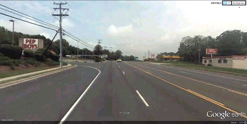
 looking north on US Route 1, Woodbridge, VA (via Google Earth)
What many people with limited time would understandably do in that situation, instead, is attempt to cross the road using the shortest and most direct route between Pep Boys and Wendy’s, and hope their instincts and powers of observation would enable them to do so without getting hit.  Some people do exactly that, without consequence.
But other pedestrians aren’t so lucky.  If they do get hit by a motor vehicle, under Virginia law the pedestrian is at fault for “interfering with traffic.”  Cars come first in the eyes of the law, and anyone who fails to respect that axiom takes chances in more ways than one.
I mention all this because it’s more or less what actually happens on this stretch of Route 1.  Videographer Jay Mallin has made a video about it.  It’s at the bottom of this post, it’s good, and you should watch it.  But first allow me to take a bit more of your time by setting the context.
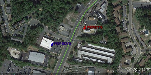
 Pep Boys and Wendy's on Route 1 (via Google Earth)
I was reminded of this story while browsing some articles I had saved on my Google Reader, one of which was “How pedestrians interfere with traffic,” written by the astute and prolific David Alpert on the Greater Greater Washington blog.  David was impressed with Mallin’s video, which tells the story of two men who were hit by motor vehicles while trying to cross the road in separate incidents near the section of Route 1 that I marked.  (You can see the Wendy’s in the background of the video.)  Both pedestrians were evacuated to the hospital, and both were charged by police with interfering with traffic.  The drivers were not charged.
Some would-be pedestrians in similar circumstances suffer far worse consequences, unfortunately.  As some readers may remember, in 2011 a working single mother named Raquel Nelson was convicted of homicide after her four-year-old son was killed while both were trying to cross a busy road in suburban Atlanta.  They were on their way home, carrying groceries after getting off the bus at a stop with no convenient crosswalk.  As I wrote then, whatever Nelson’s legal culpability, I find it shocking that Atlanta officials chose to exercise their discretion to prosecute her for homicide under those circumstances.  At least in that case the driver, who had been drinking and taking painkillers, and who had fled the scene, was also charged.
The nonprofit advocacy coalition Transportation for America (NRDC is a member) has found that, from 2000 through 2009, more than 47,700 pedestrians were killed in the United States.  This is the equivalent of a jumbo jet full of passengers crashing roughly every month.  On top of that, more than 688,000 pedestrians were injured over the decade, a number equivalent to a pedestrian being struck by a car or truck every 7 minutes.
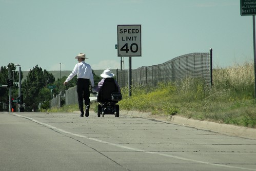
   Tom Mason, courtesy of Transportation for America)
Even if you’re not killed or injured, you can't help but find much of suburban America inhospitable to walking.  Just this week, Ben Ross reported in Greater Greater Washington that it took him eight and a half minutes to cross legally to the other side of a Maryland street, traversing 28 traffic lanes along the way.  Two pedestrians had been severely injured at the same intersection earlier this month.  Is it any wonder that, in the US, those with a choice choose to drive even the shortest of distances?
In 1973, sixty percent of American kids walked to school; by 2006, that portion had dropped to a paltry 13 percent.  As a sign that times have changed, a story surfaced a few years ago that a mom and her 12-year-old son in Saratoga Springs, New York, were actually forbidden to ride bikes together to the son’s school, even on a bike path separated from car traffic.  On the other side of the country, Laguna Beach refused to join over 400 California communities participating in International Walk to School Day, a supervised event, because “there are few sidewalks, winding roads with blind corners and a considerable distance for our students to travel and we cannot endorse walking or biking to school.”
In Montgomery County, Maryland, the local Department of Transportation refused parents’ request for a crosswalk linking a large residential development to an elementary school right across the street because “the safest way is to have them bused to school” instead.  If walking is no longer safe and convenient in relatively upscale Saratoga Springs and Laguna Beach, how are we going to fix a suburbanizing place whose residents may struggle to afford cars and arguably are even more in need of good alternatives?
 intersection that puts people first (by and courtesy of Dhiru Thadani)
Jeff Speck’s current book Walkable City provides some answers, but they aren’t going to work everywhere.  His “ten steps of walkability” to create urban environments more conducive to foot travel include such effective measures as placing more housing downtown, restricting free parking, and coordinating transit with nearby land uses.  If we do these things in Boise or Houston or Greensboro or even Bakersfield, it is likely that we will, indeed, make the city more walkable.
But can we have a walkable city where we don’t have a city in the first place?  What if the location is just a “census-designated place” with a bunch of uncoordinated and unplanned properties that somehow ended up near each other along a high-speed road?  The stretch of Route 1 in Woodbridge is not remotely ready for sophisticated measures. 
I suppose one answer is that, as the economy allows new businesses and homes to be built in and around the bad stuff, we gradually can make the newer land uses better and more “walk-ready” over time, so that the place can function better for pedestrians when the good stuff reaches critical mass.  That might take a while, though, because many of these places are not the kind of prosperous communities where change can occur rapidly and with the degree of investment necessary to do it right.
Maybe Jeff could write a sort of prequel to his book (easy for me to say), with ten preliminary steps to get a mess of a place such as Route 1 in Woodbridge ready for the ten steps of walkability featured in his current one.
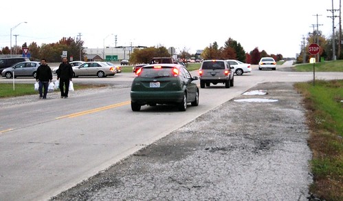
  Arthur Wendel, courtesy of Transportation for America)
Whatever the right approach, it matters:  a lot of places in America are a lot like Woodbridge.  And, if we don’t start exercising more, including by walking, the prospects for our collective health are daunting.  The single most alarming public health trend in the United States today is the dramatic rise in overweight and obesity, bringing serious risks of heart disease, diabetes and other consequences leading to life impairment and premature death.
While these are complex challenges, and there are many factors at play, our country’s sedentary lifestyle is an important one.  In a massive study of half a million residents of Salt Lake County, researchers at the University of Utah found that an average-sized man weighed 10 pounds less if he lived in a walkable neighborhood – “those that are more densely populated, designed to be more friendly to pedestrians and have a range of destinations for pedestrians” – versus a less walkable one.   A woman of average size weighed six pounds less.   Other research has found that men and women age 50–71 who took a brisk walk nearly every day had a 27 percent reduced death rate compared to non-exercisers.
This isn't the first time I have written on this subject, and it certainly won't be the last.  It's too important to ignore.
Now, as promised, here’s the video:
Kaid Benfield is director of sustainable communities at The Natural Resources Defense Council in Washington, DC. This blog also appeared on NRDC Switchboard where Kaid writes (almost) daily about community, development, and the environment.

For more in-depth coverage: 
Subscribe to Better! Cities & Towns to read all of the articles (print+online) on implementation of greener, stronger, cities and towns.
• Get the December 2012 issue. Topics: Sprawl versus walkable: Housing study, Nashville code creates value, Wake up call from Sandy, Downtown Columbia, Smart growth at the polls, Buffalo code reform, Housing and driving costs, Comparing new urban and conventional development, NorthWest Crossing, Alexander's The Battle for the Life and Beauty of the Earth
• Get New Urbanism: Best Practices Guide, packed with more than 800 informative photos, plans, tables, and other illustrations, this book is the best single guide to implementing better cities and towns".

Fonte e imagens: http://bettercities.net/news-opinion/blogs/kaid-benfield/19343/disturbing-and-sometimes-tragic-challenge-walking-america

Manual de Boas Práticas em Espaços Verdes

"Os espaços verdes são concebidos para cumprirem determinados objectivos gerais e particulares considerando as condições físicas em que vão ser instalados e mantidos. Neste capítulo são revistos os aspectos fundamentais a ponderar no processo de concepção dos espaços verdes, incluindo factores económicos, ambientais, sociais e estéticos.

O sucesso dos espaços verdes depende em grande medida de factores ambientais locais, como o solo e a água, porque estes influenciam directamente o estabelecimento e o crescimento das plantas seleccionadas para constituírem a essência desses lugares. São, por esse motivo,desenvolvidos neste capítulo os temas da preparação do solo, rega, drenagem e a selecção e instalação de relvados e de árvores, arbustos e herbáceas. À medida que se expandem para áreas naturais, as cidades podem passar a incorporar alguns dos elementos originais dessas áreas que funcionarão no futuro como espaços verdes.

É apresentado, por isso, neste capítulo um conjunto de indicações muito valiosas quanto à preservação de árvores em locais de construção. Serão finalmente abordadas opções de utilização de materiais inertes, mobiliário, pavimentos e outros elementos.

O sucesso dos espaços verdes depende em grande medida de factores ambientais áreas naturais, as cidades podem passar a incorporar alguns dos elementos originais dessas áreas que funcionarão no futuro como espaços verdes.

É apresentado, por isso, neste capítulo um conjunto de indicações muito valiosas quanto à preservação de árvores em locais de construção. Serão finalmente abordadas opções de utilização de materiais inertes, mobiliário, pavimentos e outros elementos. dos espaços verdes, incluindo factores económicos, ambientais, sociais e estéticos.locais, como o solo e a água, porque estes influenciam directamente


Download de ficheiros.
Glossário (PDF - 418 Kb)
1 Análise do local e envolvente (PDF - 425 Kb)
2 Preparação do solo (PDF - 261 Kb)
3 Rega e Drenagem (PDF - 335 Kb)
4 Selecção e instalação de espécies vegetais (PDF - 1.913 Kb)
5. Sugestão de Espécies Vegetais para as condições da cidade Bragança (PDF -189 Kb)
6. Preservação de árvores em locais de obra (PDF - 389 Kb)


Manutenção e gestão.
Uma vez instalados, os espaços verdes necessitam de um conjunto de cuidados, permanentes ou temporários, destinados a manter as suas estruturas e funções. Estes cuidados consistem em práticas diversas, aplicadas principalmente a árvores, arbustos e relvados, de forma a assegurar a sua vitalidade e sanidade bem como outros aspectos relevantes, designadamente elementos estéticos.

Incluem-se neste capítulo de manutenção e gestão as práticas ligadas à fertilização, rega e drenagem, podas de árvores e arbustos, manutenção de relvados e protecção de árvores contra agentes nocivos. Uma vez que existem riscos associados à manutenção de árvores de grande porte em espaços urbanos, particularmente das mais debilitadas, dedica-se um sub-capítulo à sua minimização.

Outros aspectos fundamentais da gestão de espaços verdes são a manutenção de corredores ripícolas nas cidades, elementos essenciais da sua estrutura e funcionamento, o destino a dar aos materiais resultantes das práticas de manutenção, nomeadamente os resíduos de podas e dos corte de relva, e as regras de limpeza e segurança dos espaços verdes.

São ainda descritos os métodos seguidos na complexa tarefa de recolha, análise de utilização de quantidades muito elevadas de informação relativa aos espaços verdes e aos seus elementos constituintes. tão as práticas ligadas à fertilização, rega e drenagem, podas de árvores e arbustos, manutenção ripícolas nas cidades, elementos essenciais da sua estrutura e funcionamento, o destino a dar aos materiais resultantes das práticas de manutenção, nomeadamente os resíduos de podas e dos corte de relva, e as regras de limpeza e segurança dos espaços verdes.

São ainda descritos os métodos seguidos na complexa tarefa de recolha, análise de utilização de quantidades muito elevadas de informação relativa elementos estéticos.

Incluem-se neste capítulo de manutenção e gestão de relvados e protecção de árvores contra agentes nocivos. Finalmente, dedica-se atenção ao envolvimento e participação da população na gestão dos espaços verdes porque estes só fazem sentido se considerados em conjunto com os seus utilizadores que podem desempenhar um papel fundamental na sua gestão e na sua manutenção nas melhores condições.


Download de ficheiros.
7. Fertilização (PDF - 210 Kb)
8. Rega (PDF - 464 Kb)
9 Relvados (PDF - 611 Kb)
10 Manutenção de Árvores (PDF - 568 Kb)
11 Manutenção de Arbustos (PDF - 663 Kb)
12 Protecção das árvores contra agentes nocivos (PDF - 883 Kb)
13 Árvores de risco (PDF - 604 Kb)
14 Linhas de água e galerias ripícolas (PDF - 224 Kb)
15 Inventário e Gestão da Informação (PDF - 1.523 Kb)
16 Resíduos de Jardim (PDF - 190 Kb)
17 Envolvimento e part. da população na gestão dos espaços verdes (PDF - 249 Kb)
18 Segurança e higiene nos espaços verdes (PDF - 230 Kb)"